Mapping Made Easy with a Drone
One of the most important things we do for customers on commercial job sites is measure dirt. Yes, you read that right! Measuring dirt helps us precisely craft the project and ensures the work is billed in a correct and timely manner.
In 2016, we started using a drone with a special camera to enhance this process. The drone provides several big benefits, including:
- Gathering much more data in less time, allowing project managers to keep better track of workflow schedules.
- Streamlining the contour mapping process so it’s less time intensive and more cost effective for customers.
- Allowing us to be more precise when billing our customers.
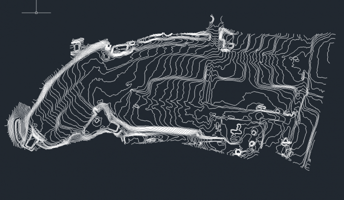
To understand the advantages of having a drone, consider the difference it makes on our topographical maps. Comparing “before” and “after” maps is how we measure dirt being moved at a given time.
“Our old maps were made from 50-foot grids,” explained Kevin Capps. He has been a GPS technician at S.T. Wooten for 15 years. That means that the GPS would record a new data point every 50 feet. We’d use the computer to determine the height difference between those points.
The new maps have a 1-inch grid and track 600 times more data. This means that we can detect more tiny changes in the height of the dirt.
Flights also take only minutes with the drone. “In one flight, I get the same amount of data that those pre-GPS guys could get in a week,” Capps said.
Streamlined workflow, more accurate measurements and more precise billing for our customers. It’s all in a day’s work with the help of our drone.

